The place · Saale-Unstrut

The Blütengrund

This is the name of the spit of land we are on: where the Unstrut flows into the Saale, north of Naumburg, opposite the vineyard slopes. The name, roughly “blossom ground”, is older than any campsite, and our emblem owes its blossom to it.

Stay What's coming

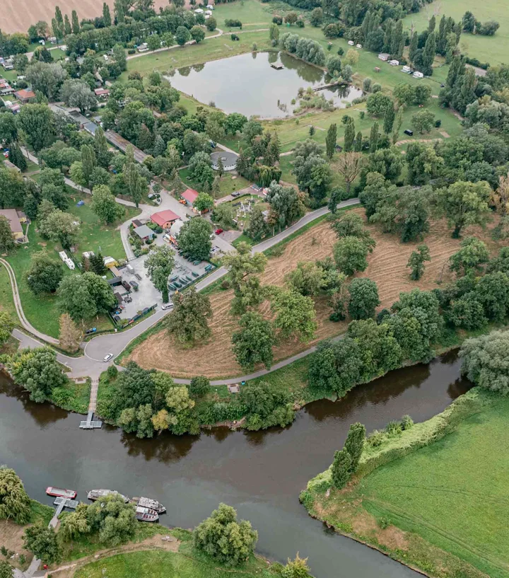
Aerial view of the Blütengrund campsite: the lake in the middle, paths and meadows beneath rows of old trees, at the bottom the Unstrut joining the Saale, with boat jetties
The site from above: the lake in the middle, the Unstrut joining the Saale at the bottom · Aerial photo © Stadt Naumburg · 2025 feasibility study, © Lauer + Lebok Architekten

Since 1967

A place with a past

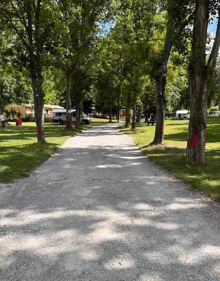
Gravel path beneath tall old trees at the Blütengrund campsite, caravans and a motorhome in the background
The northern access path: this is what the site looks like today · Photo © Stadt Naumburg · 2025 feasibility study, © Lauer + Lebok Architekten

The lake at the centre of the site was created in 1967: man-made, fed by groundwater, almost rectangular, set in a funnel-shaped basin of banked-up earth whose sloping sides served as a sunbathing lawn. Until 2004 it was a public natural swimming lake and, as the town's feasibility study puts it, a meeting place for young and old from Naumburg and the surrounding area. Most people came by bike. Photos from the 1970s and 1980s show the lake full of bathers, music on the shore and a car park crammed with bicycles.

The diving tower is gone. The diving platform still stands at the deepest point, on its concrete foundations. The concrete jetty from the south bank into the lake is still there too.

In 2004 the lake closed to swimmers; the water quality was no longer good enough. Since then it has been an ornamental lake and fishing water for the local angling club, a habitat rather than a bathing spot. Signs on the shore say what the rule has been ever since.

The campsite kept running but was not developed further: much of the investment agreed in the 2006 lease never materialised. What we are taking over is a site with a superb location and old trees. And with more than twenty buildings that have to be demolished.

From 2027 Blytengrund GmbH runs the Blütengrund campsite. We are rebuilding it: opening on 1 March 2027 with 120 pitches, then further building work until 2030 while the site stays open. The natural swimming lake is planned to reopen on 1 May 2029. How we get there is set out under What's coming.

Until then the lake is not a bathing spot. Swimming has been prohibited since 2004. You may look at it and walk round it, but not go in.

1967

The lake is created and opens for swimming

2004

Swimming ends; from then on the lake is ornamental

2027

Reopening in March with 120 pitches

2029

Natural swimming lake from 1 May: planned, not promised

Until 2004 the lake and the site around it were a meeting place for young and old from Naumburg and the surrounding area. We want it to be exactly that again.

Blytengrund GmbH

Saale and Unstrut

The two rivers

The Unstrut comes in from the north-west, out of wine country; the Saale comes up from the south, by way of Bad Kösen and Naumburg. Here at the Blütengrund they flow together. To see it for yourself, walk a few steps: there is a bench where the rivers meet.

The bank is not far: between the grounds and the river runs the cycling and walking path along the Saale. The Saale cycle route passes right by the site, and the Unstrut cycle route joins it here. At the north-west corner of the site a passenger ferry crosses the Saale.

The way onto the water is by canoe. The hire company Saale-Unstrut-Tours is on the grounds, and the Naumburg canoe club borders the site directly to the north. Anyone touring the Saale or the Unstrut by canoe has the site on their map: canoe hire right here, the tent meadow within reach.

Until 2029 the lake stays what it is today: a habitat and an eye-catcher, not a place to swim. Two rivers and a lake are the reason the first of our three pillars is called Water.

Three pillars

Water, wine and wild meadows

This place rests on three themes. Each has three sides: something to experience, something to do and something to enjoy.

Water

Two rivers, a lake, a canoe hire.

Experience

The confluence of the Unstrut and the Saale is right on the doorstep, with the floodplain all around. At the centre of the site lies the lake of 1967: today a habitat and fishing water, and from 2029, according to the plan, a natural swimming lake again.

Activity

Canoeing from the grounds, cycling the Saale cycle route straight from the site, taking the ferry across the river. From 2029, if all goes to plan, the natural swimming lake for guests and the people of Naumburg.

Taste

The outdoor seating of the restaurant faces the lake, with a view across the lawn. A kiosk by the water follows in 2029.

Wine

The slopes begin within sight.

Experience

Saale-Unstrut is one of Europe's northernmost wine regions. The vineyard slopes lie opposite the site; the state winery at Kloster Pforta is a few kilometres upstream in Schulpforte.

Activity

Wine trails lead from the site into the vineyards. The Saale-Unstrut Wine Route links the wine villages of both river valleys.

Taste

In the Genusskontor, our shop on the site, and in the restaurant we stock wines from the region: a selection from growers we know, not a wall of shelves.

Wild meadows

Riverside woodland, wet meadows, old trees.

Experience

The Blütengrund lies in the Saale floodplain. Wet meadows, old trees and the veteran oaks in the neighbouring meadow shape the grounds, and they are staying.

Activity

On foot through the floodplain meadows west of the site. On the grounds: a lawn to relax on, play equipment, mini golf, volleyball, basketball and a kickabout pitch, some of it open to people from Naumburg too.

Taste

Breakfast outside, regional produce from the Genusskontor, the restaurant's outdoor seating in the evening. Here, summer happens in the open air.

The region

What you can reach from here

The Blütengrund lies outside town, but not far from it: Naumburg's old town is about three kilometres away. There is a connection to the A 9 motorway, Naumburg and Bad Kösen have railway stations, and Leipzig, Halle, Jena and Weimar are all less than an hour away.

The easiest way to explore the region is by bike. The Saale cycle route passes the site, and the Unstrut cycle route joins it here. Routes and stages are available from Saale-Unstrut-Tourismus e. V., the regional tourism association.

Two bicycles leaning against a bench by the path, the sun setting over meadows behind them
Illustrative image, AI-generated

Großjena on the far bank

On the left bank of the Unstrut, directly opposite the confluence: the Steinernes Bilderbuch (“stone picture book”) of 1722, a sandstone relief 200 metres long showing winegrowers and scenes from the Bible, and the vineyard of the artist Max Klinger. His country house is a branch of the Naumburg museum, open April to October; he is buried there.

Naumburg Cathedral

A UNESCO World Heritage site, about three kilometres from the campsite. The founder figures in the west choir are among the most significant works the Middle Ages left behind in Germany.

Naumburg

A cathedral town of around 34,000 people, with an old town and market square, the Nietzsche House and the Hohe Lilie town museum. Shops, doctors and the station are close enough that the campsite does not need to be a town in itself.

Wine Route and wineries

The Wine Route links the wine villages of both river valleys; in Naumburg there is the Wein- und Sektmanufaktur for still and sparkling wine. [To be confirmed: wineries and seasonal wine taverns within walking distance]

Schulpforte

The state winery at Kloster Pforta with its visitor centre, a few kilometres upstream on the Saale.

Bad Kösen

A spa town upstream on the Saale, with a graduation tower, thermal baths and its own railway station. From there it is not far to the castles above the valley.

Castles and palaces

Burg Saaleck and the Rudelsburg, two castles above the Saale valley near Bad Kösen, and Schloss Goseck as well. [To be confirmed: distances from the site]

Swimming: elsewhere until 2029

If you want to swim: the Bulabana leisure pool in Naumburg, the thermal baths in Bad Kösen. The lake on the site remains a habitat until the natural swimming lake opens.

Nature

Camping in a park

A family with a dog on a path through tall meadow grass, a river behind them
Illustrative image, AI-generated

Almost the entire site lies within the flood zone of the two rivers. That decides where building is allowed: on four small areas around the lake that stay above flood level. Most of the land remains meadow.

The wildlife was surveyed during planning. At least four species of bat hunt over the Blütengrund, most often the common pipistrelle and the noctule; a summer roost was found in a woodpecker hole in an ash tree. Amphibians have been recorded, and grass snakes occasionally come in from the riverbanks. The trees on the site and the veteran oaks in the meadow to the west are considered particularly valuable. That is why the planning works around them, not through them.

The study's guiding idea is camping in a park: instead of open lawns, wildflower meadows, perennials and loose groups of trees and shrubs divide up the pitches, and what is planted is native to the area. In the south, new habitats are being created as ecological compensation.

Today the lake is a habitat rather than a bathing spot. It stays that way until 2029; after that it is meant to be both: a natural swimming lake and a home for wildlife, with shore zones where plants clean the water.

Partner

Saale-Unstrut-Tourismus e. V.

The Blütengrund campsite is a partner of Saale-Unstrut-Tourismus e. V., the regional tourism association. If you want to plan beyond the campsite, that is where to find everything else: cycle routes, the Wine Route, events.

From 1 March 2027 we are here for you.

Pitches, the tent meadow and, from 2028, tiny houses: what is available and when.

Stay at the Blütengrund